Friday, 3 September 2010

New York City Waterfalls


New York City Waterfalls is an art installation by artist Olafur Eliasson, in collaboration with the Public Art Fund, consisting of four man-made waterfalls placed around New York City along the East River.


At $15.5 million, it is the most expensive public arts project since Christo and Jeanne-Claude's installation of The Gates in Central Park. The waterfalls officially began flowing on June 26, 2008. They will run from 7 am to 10 pm (under illumination after sunset), until October 13, 2008.

The sites chosen for the four waterfalls were Pier 35 in Manhattan, beneath the Brooklyn Bridge in DUMBO, Brooklyn, between piers 4 and 5 — also in Brooklyn — and Governors Island.
Work on erecting the four support scaffolds began in mid-March, 2008. On the shore of Governors Island construction teams used pile driving to secure the scaffolding in place. This method was not used at the other locations for various reasons, including the effects of vibrations through car and subway tunnels. Once completed, the scaffolding would total 64,000 square feet and weigh 270 tons. Eliasson has said that the scaffolds themselves were designed to blend in with their urban surroundings, but that he purposely did not try to conceal them, explaining he "want[s] people to know that this is both a natural phenomenon and a cultural one.”
Construction involved the work of 108 different people, including two environmental consultants. The installation was designed to be ecologically-friendly. Some example of this are energy efficient LED lighting, energy purchased from renewable sources and the filters used to keep aquatic life from taking a ride up-and-over the waterfall. When the project has closed the materials will be made available for re-use in a future project

Colorado State Capitol


Built to last 1,000 years, the capitol was constructed in 1886 of granite from a Colorado quarry. The dome, which rises 272 feet above the ground, was first sheathed in copper and then replaced with gold leaf after a public outcry: Copper was not a Colorado product.


Murals depicting the history of water in the state adorn the walls of the first-floor rotunda, which offers a splendid view upward to the underside of the dome. The rotunda resembles the layout of the U.S. Capitol in Washington, D.C. South of the rotunda is the governor's office, paneled in walnut and lit by a massive chandelier.


On the first floor, the west lobby hosts revolving temporary exhibits. To the right of the main lobby is the governor's reception room. The second floor has main entrances to the House, Senate, and old Supreme Court chambers. On the third floor are entrances to the public and visitor galleries for the House and Senate

Los Cabos


Los Cabos is a municipality located at the southern tip of Mexico's Baja California Peninsula, in the state of Baja California Sur. It encompasses the towns of Cabo San Lucas and San José del Cabo, as well as the Resort Corridor that lies between the two. The area's economy, like many resort areas in Mexico, was based on fishing but is now geared towards tourism, though sport fishing is one of the area's main attractions.


One of Mexico's most scenic wonders, Los Cabos ("the Capes") is many things to many people: a desert oasis, a hot spot for night life, a traditional village, and an award-winning resort destination. EI Arco, a natural stone arch formed where the Sea of Cortes meets the Pacific Ocean, stands as a monument to the area's breathtaking contrasts.Los Cabos is made up of two distinctly alluring small towns-San Jose del Cabo to the northeast and Cabo San Lucas at the southern tip. Picturesque San Jose del Cabo, a sleepy 18th-century mission town, appeals to those in search of more than the wiles of modern resorts. The town is home to many artists, whose wares are often on display and for sale in the village square.

Twenty miles down the coast, Cabo San Lucas pulses with shops, restaurants, and nightclubs. Those in search of lively beaches, kayak excursions, dancing to the wee hours, sunset cruises, and such will find Cabo San Lucas just their speed. Connecting the two towns is a coastal "corridor," along which lie resorts both grand and intimate and many famous golf courses. One side of the corridor offers endless views of sand and sea, while along the other side is the quiet desert, with the majestic mountains beyond.

Wotans Throne


Wotans Throne is a mountain summit in Inyo County in the state of California (CA). Wotans Throne climbs to 12,717 feet (3,876.14 meters) above sea level. Wotans Throne is located at latitude - longitude coordinates (also called lat - long coordinates or GPS coordinates) of N 36.566324 and W -118.279535.

Anyone attempting to climb Wotans Throne and reach the summit should look for detailed information on the Wotans Throne area in the topographic map (topo map) and the Mount Whitney USGS quad. To hike and explore the California outdoors near Wotans Throne, check the list of nearby trails.

Daytona Beach - Florida

Daytona Beach is a city in Volusia County, Florida, USA. According to 2006 U.S. Census Bureau estimates, the city has a population of 64,421. Daytona Beach is a principal city of the Deltona-Daytona Beach-Ormond Beach, Florida Metropolitan Statistical Area, which the census bureau estimated had a 2006 population of 496,575.


Daytona Beach is a year-round resort area. The city is historically known for its motorsports, with both Daytona International Speedway and the old Daytona Beach Road Course having hosted races for over a century. The city is also the headquarters for NASCAR and the Grand American Road Racing Association. Daytona could accurately be called a seasonal town, with large groups of out-of-towners descending upon the city for various events, most notably Speedweeks in early February when over 200,000 NASCAR fans come to attend the season-opening Daytona 500. Other events include the NASCAR Pepsi 400 race in July (now Coke Zero 400), Bike Week in March, Biketoberfest in October and Black College Reunion in March and April. In the past Daytona Beach catered to spring breakers, but in recent years many of the breakers have migrated to other sites, like Panama City Beach. Daytona Beach has tried to clean up its image but in the last few years spring breakers have come back again in smaller numbers


Daytona Beach is located at 29°12′26″N 81°02′16″W / 29.207309, -81.037900.[7] According to the United States Census Bureau, the city has a total area of 64.93 mi² (168.17 km²). of which 58.68 square miles (152 km2)is land and 6.25 square miles (16 km2) is water. Water is 9.6% of the total area.

The city of Daytona Beach is split in two by the Halifax River lagoon, part of the Intracoastal Waterway, and sits on the Atlantic Ocean. It is bordered on the north by Holly Hill and Ormond Beach and on the south by Daytona Beach Shores, South Daytona and Port Orange. The major highways that serve the city are the east-west Interstate 4 and the north-south Interstate 95, which intersect near the city. Other major roads in the city include US 92/International Speedway Boulevard, U.S. 1/Ridgewood Avenue and A1A/Atlantic Avenue.


Daytona Beach has a humid subtropical climate, typical of the southeastern United States. Summers are hot and humid with highs usually in the 90s and a heat index often exceeding 100 degrees. Thunderstorms are frequent in summer afternoons and the hot, humid weather can last right through the fall months. Winters are dry and mild, marked by a constant series of cold fronts and warm-ups. Temperatures dip into the low 30s and upper 20s on occasion, and freezes are not uncommon. Frost occurs a few times a year mainly in the inland areas, but is rare along the beaches. Snowfall is very rare. Temperatures in spring are famously pleasant with warm afternoons, cool evenings, and far less humidity. This beach-going weather attracts tourists back to the beaches usually by early March.


The Baffling Bermuda Triangle

The Bermuda Triangle (also known as Devil's Triangle) is a nearly half-million square-mile (1.2 million km2) area of ocean roughly defined by Bermuda, Puerto Rico, and the southernmost tip of Florida. The Bermuda Triangle became popular through representation by the mass media as a paranormal site in which the known laws of physics are either violated, altered, or both.
One of the classic disappearances is Flight 19, a flight of Avenger TBMS (torpedo bomber medium)that dissapeared on December 5th 1945 while on a training flight.The squadron Leader Lt (jg)Charles Taylor reported being in trouble and disoriented 40 minutes into the flight. The controllers at Ft. Lauderdale tried to offer assistance, but lost contact with Flight 19. It has never been found.

While there is a common belief that a number of ships and airplanes have disappeared under highly unusual circumstances in this region, the United States Coast Guard and others disagree with that assessment, citing statistics demonstrating that the number of incidents involving lost ships and aircraft is no larger than that of any other heavily traveled region of the world. Many of the alleged mysteries have proven not so mysterious or unusual upon close examination, with inaccuracies and misinformation about the cases often circulating and recirculating over the decades.

Everything from aliens to electromagnetic energy has been used to explain the triangle.

The area known as the Bermuda Triangle encompasses 2,414,016 sq. km (941,466 sq. miles) of open sea between Bermuda, Puerto Rico, and the southeastern shoreline of the U.S. This bit of the Atlantic is the source of the most famous, and certainly the most baffling, legend associated with Bermuda.

Tales of the mysterious Bermuda Triangle persist, despite attempts by skeptics to dismiss them as fanciful. Below are three of the most popular. Can they be true? See what you think:
In 1881, a British-registered ship, the Ellen Austin, encountered an unnamed vessel in good condition sailing aimlessly without a crew. The captain ordered a handful of his best seamen to board the mysterious vessel and sail it to Newfoundland. A few days later, the ships encountered each other again on the high seas. But to everyone's alarm, the crewmen who had transferred from the Ellen Austin were nowhere to be found -- the ship was completely unmanned!
Another tale concerns the disappearance of a merchant ship, the Marine Sulphur Queen, in February 1963. It vanished suddenly without warning, and no one could say why. The weather was calm when the ship set sail from Bermuda, and everything onboard was fine -- the crew never sent a distress signal. In looking for explanations, some have theorized that the ship's weakened hull gave way, causing the vessel to descend quickly to the ocean floor. Others attribute the loss to more mysterious forces.

The most famous of all the legends concerns an incident in 1945. On December 5, five U.S. Navy bombers departed from Fort Lauderdale, Florida, on a routine mission. The weather was fine; no storm of any kind threatened. A short time into the flight, the leader of the squadron radioed that they were lost, and then the radio went silent. All efforts to establish further communication proved fruitless. A rescue plane was dispatched to search for the squadron -- but it, too, disappeared. The navy ordered a search that lasted 5 days, but there was no evidence of any wreckage. To this day, the disappearance of the squadron and the rescue plane remains a mystery as deep as the waters of the region.

How do those who believe in the Bermuda Triangle legend account for these phenomena? Some contend that the area is a time warp to another universe; others think the waters off Bermuda are the site of the lost kingdom of Atlantis, whose power sources still function deep beneath the surface. Still others believe that laser rays from outer space are perpetually focused on the region, or that underwater signaling devices are guiding invaders from other planets, and that these aliens have chosen the site for the systematic collection of human beings for scientific observation and experimentation. (Smacks of The X-Files, doesn't it?) Some, drawing upon the Bible's Book of Revelation, are fully persuaded that the Bermuda Triangle is really one of the gates to Hell (in this version, the other gate lies midway between Japan and the Philippines, in the Devil's Sea).

No matter what your views on these mysteries, you're bound to provoke an excited response by asking residents what they think about it. On Bermuda, almost everyone has an opinion about the island's biggest and most fascinating legend.


Maui Island


The island of Maui is the second-largest of the Hawaiian Islands at 727.2 square miles (1883.5 km²) and is the 17th largest island in the United States. Maui is part of the state of Hawaii and is the largest island in Maui County. Three other islands, Lanai, Kahoolawe, and Molokai, also belong to Maui County. Together, the four islands are known as Maui Nui. In 2000, Maui had a population of 117,644, the third-largest of the Hawaiian islands, behind that of Oahu and Hawaii. Kahului is the largest town on the island with a population of 20,146. Wailuku is the seat of Maui County.


Maui County welcomed 2,207,826 tourists in 2004; 2,263,676 tourists in 2005; and 2,405,257 tourists in 2006 with total tourist expenditures of US$3.5 billion for the Island of Maui alone. While the Island of Oahu is most popular with Japanese tourists, the Island of Maui tends to appeal to visitors mostly from the U.S. mainland and Canada: in 2005, there were 2,003,492 domestic arrivals on the island, compared to 260,184 international arrivals. The big tourist spots in Maui include the Road to Hana, Haleakala National Park, and Lahaina.
The Road to Hana is a highway that runs along the east coast Maui which curves along many mountains and beaches. Even though the drive is very long and curvy, the beautiful waterfalls and black sand beaches are well worth it. Haleakala National Park is home to one of the most beautiful sunrises in the world. Drive up the cold, dormant volcano to view the sunrise, but be sure to bring some blankets because it is much different from the weather during the day at the beach. The temperature from atop the summit can be as much as 32 degrees colder than the resort areas. Lahaina is one of the main attractions on the island with an entire street of shops and restaurants which lead to a wharf where many set out for a sunset cruise or whale watching journey. Snorkeling with exotic underwater creatures can be done at almost any beach along the Maui coast.
The main tourist hotel and condo areas are West Maui (Kaanapali, Lahaina, Honokowai, Kahana, Napili, Kapalua), and South Maui (Kihei, Wailea).
In April of 2008, Hawaii suffered a major loss in tourism due to the bankruptcies from both ATA and Aloha Airlines. The increased demand on the remaining airlines forced prices up, making travel to Hawaii less desirable


The Bulgarian Black Sea


The Bulgarian Black Sea coast is 380 km marvelous beaches with fine golden sand and natural dunes; calm and safe sea with low sloping sandy bottom and clear water; numerous mineral springs and beautiful nature. The Black sea water is amazingly smooth and is nearly fresh according to the Mediterranean and it is a real pleasure to swim or dive within. Holiday-makers have a huge selection of activities to choose from like yachting, diving, windsurfing, water skiing, snorkeling, underwater fishing and other aquatic sports.

The Bulgarian Black Sea Riviera (Bulgarian: Черноморие, Chеrnomoriе) covers the entire eastern bound of Bulgaria stretching from the Romanian Black Sea Riviera in the north to European Turkey in the south, along 378 km of coastline. White and golden sandy beaches occupy approximately 130 km of the 378 km long coast. The region is an important center of tourism during the summer season (May-October), drawing millions of foreign and local tourists alike and constituting one of the country's most popular tourist destinations. Prior to 1989 the Bulgarian Black Sea coast was internationally known as the Red Riviera. Since the fall of the Iron Curtain, however, it's nickname has been changed to the Bulgarian Riviera.
The area's average air temperature in the summer is about 28°C, with the average water temperature at 25°C. There are more than 240 hours of sunshine in May and September and more than 300 hours in July and August.


The Balkan Mountains cross the country reaching to the edge of the Black Sea at Cape Emine, dividing the coastline into a southern and northern part. Parts of Bulgaria's northern Black Sea Coast feature rocky headlands where the sea abuts cliffs up to 70 metres in height. The southern coast is known for its wide sandy beaches.
The two largest cities and main seaports on the Bulgarian Riviera are Varna (third largest in the country) and Burgas (fourth largest in the country). Varna is located on the northern part of the coast and Burgas is located on the southern coast. The two cities' international airports, Varna Airport and Burgas Airport, are the main hubs servicing the region. In addition, the A1 and A2 motorways, currently in construction, would make the trip from the capital Sofia to the coast substantially easier and faster, while the A3 is planned to connect Varna and Burgas.


Fatehpur Sikri


Built from scratch in 1571 by Akbar in honor of the Sufi saint Salim Chisti, who had predicted the birth of a son, this grand ghost city is carved entirely from red sandstone. It was only inhabited for 14 years, after which -- some say because of water shortages -- it was totally abandoned. It's a bizarre experience to wander through these magnificent, architecturally fascinating sandstone arches, courtyards, and buildings.

The buildings combine a fine sense of proportion -- indicative of Akbar's Persian ancestry -- with strong Hindu and Jain design elements, indicative again of his embracing attitude to the conquered and their faiths. Upon entering, you will see Diwan-i-Khas, thought to be a debating chamber, on the right. Facing it is Ankh Michali, thought to be the treasury, which has mythical Hindu creatures carved on its stone struts. To the left is large Parcheesi Court, where Parcheesi (from which games such as backgammon and ludo were subsequently derived) was played with live pieces: the ladies of the harem. It is said that Akbar learned much about the personalities of his court and enemies by watching how they played, won, and lost. Surrounding the court are, from the left, Diwan-i-Am, a large pavilion where public hearings were held; the Turkish Sultana's House, an ornate sandstone pavilion; and Abdar Khana, where drinking water and fruit were apparently stored.

Walk between the two latter buildings to enter Akbar's private quarters. Facing Anoop Talao -- the four-quartered pool -- are the rooms in which he slept and his personal library with shelves carved into the walls. Also overlooking Parcheesi Court is Panch Mahal, the tallest pavilion, where Akbar's wives could watch the games and enjoy the breeze without being seen. Behind Panch Mahal are the female quarters, including Maryam's House and the Haram Sara Complex. The harem leads to Jodha Bai's Palace, a large courtyard surrounded by pavilions -- note the green glazed roof tiles. To the east is Birbal's House, a two-story pavilion noted for its carvings; beyond lie the servants' cells. From here you exit to visit Jama Masjid, a mosque even more spectacular than the larger one Akbar's grandson built in Delhi. Set like a glittering pearl amid the towering red-sandstone bastions, punctuated by a grand gateway, is the white marble dargah (tomb) of Salim Chisti, which has some of the most beautiful carved screens in India. It attracts pilgrims from all over India, particularly (given the good fortune he brought Akbar) the childless, who make wishes while tying cotton threads onto the screens that surround the tomb.
Again, the services of a good guide are indispensable to a visit here (don't bother hiring one of the "official" guides at the entrance, however).

Alice Springs


Alice Springs is the second largest town in the Northern Territory of Australia. Popularly known as "the Alice" or simply "Alice", it had a population of 26,486 in 2005. Averaging 576 metres above sea level, the town is nearly equidistant from Adelaide and Darwin, close to the geographic centre of Australia. The site is known as Mparntwe to its traditional inhabitants, the Arrernte, who have lived in the Central Australian desert in and around what is now Alice Springs for more than 50,000 years.

In 1861-62, John McDouall Stuart led an expedition through Central Australia, to the west of what later became Alice Springs, thereby establishing a route from the south of the continent to the north.


A settlement came into existence as a result of the construction of a repeater station on the Overland Telegraph Line, which linked Adelaide to Darwin and Great Britain.
The OTL was completed in 1872. It traced Stuart's route and opened up the interior for permanent settlement. It wasn’t until alluvial gold was discovered at Arltunga, 100 km east of the present Alice Springs, in 1887 that any significant settlement occurred. Until the 1930s, however, the town was known as Stuart.


The telegraph station was sited near what was thought to be a permanent waterhole in the normally dry Todd River and was optimistically named Alice Springs after the wife of the former Postmaster General of South Australia, Sir Charles Todd. The Todd River was named after Sir Charles himself.

The original mode of transportation in the outback were camel trains, operated by immigrants from Pathan tribes in the North-West frontier of the then British India (present-day Pakistan) who were misnamed ‘Afghan’ Camellers.

In 1929 the Palmerston and Pine Creek Railway was completed from Darwin as far as Birdum, while the Great Northern Railway had been completed in 1891 from Port Augusta as far as Oodnadatta, South Australia, 700 km south of Alice Springs.

Araluen Centre for Arts and Entertainment - Alice Springs Cultural Precinct
The lines wouldn’t meet until 2003. On February 4, 2004, the first passenger train arrived in Darwin from Adelaide.
During the 1960s it became an important defence location with the development of the U.S/Australian Pine Gap joint defence satellite monitoring base, home to about 700 workers from both countries, but by far the major industry in recent times is tourism.
Almost in the exact center of the continent, Alice Springs is some 1200 km from the nearest ocean and 1500 km from the nearest major cities, Darwin and Adelaide. Alice Springs is now the midpoint of the Adelaide–Darwin Railway.

World War II
During World War II, Alice Springs was a staging base, known as No. 9 Australian Staging Camp, and a depot base for the long four-day trip to Darwin.
The Australian Army also set up the 109th Australian General Hospital at Alice Springs. Seven mile aerodrome was also constructed by the Royal Australian Air Force.

Indigenous history

The "Springs" that gave the town its name
The Arrernte Aboriginal people[4] have made their home in the Central Australian desert in and around the site of the future Alice Springs for more than 50,000 years. The Aboriginal name for Alice Springs is Mparntwe.
Three major groups Western, Eastern and Central Arrernte people live in Central Australia, their traditional land including the area of Alice Springs and East/West MacDonnell Ranges. They are also referred to as Aranda, Arrarnta, Arunta, and other similar spellings. Their neighbours are the Southern Arrernte, Luritja, Anmatyerr, Alyawarr and Western Arrernte peoples. There are five dialects of the Arrernte language: South-eastern, Central, Northern, Eastern and North-eastern.
Arrernte country is rich with mountain ranges, waterholes, and gorges; as a result the Arrernte people set aside 'conservation areas' in which various species are protected.
According to the Arrernte traditional stories, in the desert surrounding Alice Springs, the landscape was shaped by caterpillars, wild dogs, travelling boys, two sisters, euros, and other ancestral figures.

Alice Springs Desert Park, Sand Drawing Aboriginal
There are many sites of traditional importance in and around Alice Springs, such as Anthwerrke (Emily Gap), Akeyulerre (Billy Goat Hill), Ntaripe (Heavitree Gap), Atnelkentyarliweke (Anzac Hill), and Alhekulyele (Mt. Gillen).
There are roughly 1,800 speakers of Eastern and Central Arrernte, making it the largest spoken language in the Arandic family, and one of the largest speaking populations of any Australian language. It is taught in schools, heard in local media and local government.
Many Arrernte people also live in communities outside of Alice Springs and on outstations.

Modern town
The modern town of Alice Springs has both western and Aboriginal influences. The town's focal point, the Todd Mall, hosts a number of Aboriginal art galleries and community events. Alice Springs’ desert lifestyle has inspired several unique and interesting events such as the Camel Cup, the Henley-on-Todd Regatta and the Beanie Festival.


Built environment
Alice Springs Telegraph Station
Alice Springs has many historic buildings, such as the Overland Telegraph Station, Adelaide House, the Old Courthouse and Residency and the Hartley Street School. Today the town is an important tourist hub and service centre for the surrounding area. It is a well-appointed town for its size with several large hotels, a world class convention centre and a good range of visitor attractions, restaurants and other services.

Parks and gardens
The Alice Springs Desert Park was created to educate visitors on the many facets of the surrounding desert environment. The arid climate botanic garden, Olive Pink Botanic Garden is a short distance from the town centre. They were named after anthropologist, naturalist and artist Olive Pink, who lived in the town for almost 30 years and died in 1975. She was well known locally and referred to by all as Miss Pink. The Alice Springs Reptile Centre is located in the town centre.
The MacDonnell Ranges run east and west of Alice Springs and contain a number of hiking trails and swimming holes such as Ormiston Gorge, Ormiston Gorge Creek, Red Bank Gorge and Glen Helen Gorge. The 223 km long Larapinta Trail follows the West MacDonnell Ranges and is considered among the world's great walking experiences.
The Simpson Desert, southeast of Alice Springs is one of Australia's great wilderness areas containing giant red sand dunes and interesting rock formations such as Chambers Pillar and Rainbow Valley.


Aboriginal population
According to the 2001 census, Australian Aborigines make up approximately 17% of the population of Alice Springs, and 29% of the Northern Territory. As Alice Springs is the regional hub of Central Australia it attracts Aboriginal people from all over that region and well beyond. Many Aborigines visit regularly to use the town's services. Aboriginal residents usually live in the suburbs, on special purpose leases (or town camps) or further out at Amoonguna to the South and on the small family outstation communities on Aboriginal Lands in surrounding areas.
The traditional owners of the Alice Springs area are the Central Arrernte people. As it is the largest town in central Australia, there are also speakers of Warlpiri, Warumungu, Kaytetye, Alyawarre, Luritja, Pintupi, Pitjantjatjara, Yankunytjatjara, Ngaanyatjarra, Pertame, Eastern and Western Arrernte among others.

Kagay Anons Whitewater Rafting Adventure

Kagay-anon's Whitewater Rafting Adventure

Whitewater rafting is indeed a very exciting recreational activity which is popular all throughout the world. Before, rafting is only a means of transportation. But in this modern age, it becomes a pastime or a sport to some individuals. Rafting isn’t an easy activity. You get to encounter different classes of rapids until you get to bump into the most dangerous rapid: large waves and huge rocks. Safety is always important to this kind of activity.

Cagayan de Oro: a blooming city in Misamis Oriental province never gets too late when it comes to rapids. One of the city’s major tourism attractions are their WhiteWater Rafting Adventure. Aside from being friendly (since the city is known to be as the City of Golden Friendship), the whitewater rafting guides are also equipped with professional skills traversing the Cagayan de Oro River a couple of times.

Kagay-anon's Whitewater Rafting Adventure

Hong Kong - City of Life

clip_image001

Hong-Kong, the "city of life", designed and run by architects and entrepreneurs from around the world is a dense city of many cultures where you can find anything at anytime. It is one of the most crowded and diverse cities everywhere. It also has one of the most stunning urban landscapes in the world, especially at night where it blazes like a great flower of light with petals of neon.Hong Kong itself is divided into four main areas – Hong Kong Island, Kowloon, the New Territories and the Outlying Islands. Though each have a vital and long-standing role in Hong Kong tourism, most visitors spend the majority of their time in the densely populated area of Kowloon.

The Market Square of Antwerp


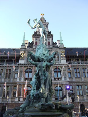
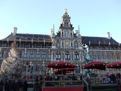
The Market Square in Antwerp is surrounded by Guild houses and the Town hall. Most of the guild houses are rebuild after they burned down in the 16th century. On the first photo you can see the town hall, a renaissance building constructed between 1561-1565.
The statue (last photo) is made by Jef Lambeaux. It was inspired by a legend of a giant who used to live on the banks of the river Scheldt. Whenever sailors on the Scheldt refused to pay toll, he punished them by cutting off their hand. A Roman soldier called Silvius Brabo, killed the giant, cut off his hand and threw it in the river.

The Magna Plaza


The Magna Plaza is a beautiful mall behind the Royal Palace in Amsterdam. It was built in 1899 in Neo-Gothic style and was once a Post Office building. Inside this four floors shopping mall are all major fashion brands represented.

Las Vegas

Las Vegas is the most dynamic, spectacular city on earth. At the start of the twentieth century, it didn't even exist; at the start of the twenty-first, it's home to well over one million people, with enough newcomers arriving to need a new school every month.

Las Vegas is not like other cities. No city in history has so explicitly valued the needs of visitors above those of its own population. All its growth has been fueled by tourism, but the tourists haven't spoiled the "real" city; there is no real city. Las Vegas doesn't have fascinating little-known neighborhoods, and it's not a place where visitors can go off the beaten track to have more authentic experiences. Instead, the whole thing is completely self-referential; the reason Las Vegas boasts the vast majority of the world's largest hotels is that around thirty-seven million tourists each year come to see the hotels themselves.

The casinos want you to gamble, and they'll do almost anything to lure you in; thus the huge moving walkways that pluck you from the Strip sidewalk, almost against your will, and sweep you into places like Caesars Palace. Once you're inside, on the other hand, the last thing they want is for you to leave. Whatever you came in for, you won't be able to do it without crisscrossing the casino floor innumerable times; as for finding your way out, that can be virtually impossible. The action keeps going day and night, and in this windowless – and clock-free – environment you rapidly lose track of which is which.


Thursday, 2 September 2010

Puerto Vallarta


PUERTO VALLARTA is smaller, quieter and younger than Acapulco. In its own way, it is actually every bit as commercial – perhaps more so, since here tourism is virtually the only source of income – but appearances count for much, and Puerto Vallarta, while doing all it can to catch up with Acapulco, appears far less developed and retains a more Mexican feel.


It lies in the middle of the 22-kilometre wide Bahía de Banderas, the seventh largest bay in the world, fringed by endless sandy beaches and backed by the jungly slopes of the Sierra Madre. Its hotels are scattered along several miles of coast with the greatest concentration in Nuevo Vallarta, north of the town and sliced through by an eight-lane strip of asphalt. Just south of Nuevo Vallarta is the new marina, where you can stroll along the boardwalk and have a look at how the other half live, on beautiful boats. Despite the frantic development of the last decade, the historic town centre, with its cobbled streets and white-walled, terracotta-roofed houses, sustains the tropical village atmosphere, an asset assiduously exploited by the local tourist authorities.

The town's relative youth is undoubtedly a contributing factor. Until 1954 Puerto Vallarta was a small fishing village where the Río Cuale spills out into the Bahía de Banderas; then Mexicana airlines, their hand forced by Aeroméxico's monopoly on flights into Acapulco, started promoting the town as a resort. Their efforts received a shot in the arm in 1964, when John Huston chose Mismaloya, 10km south, as the setting for his film of Tennessee Williams' play The Night of the Iguana, starring Richard Burton. The scandalmongering that surrounded Burton's romance with Elizabeth Taylor – who was not part of the cast but came along – is often attributed to putting Puerto Vallarta firmly in the international spotlight: "a mixed blessing" according to Huston, who stayed on here until his death in 1987, and whose bronze image stands on the Isla Río Cuale in town.


Boracay island

Boracay is a tropical island located approximately 315km (200 miles) south of Manila and 2km off the northwest tip of the island of Panay in the Western Visayas region of the Philippines. It is one of the country’s most popular tourist destinations. The island comprises the barangays of Manoc-Manoc, Balabag, and Yapak (3 of the 17 barangays which make up the municipality of Malay), and is under the administrative control of the Philippine Tourism Authority in coordination with the Provincial Government of Aklan.

boracay.jpg


bora1.jpg

Boracay Island is located off the northwest corner of the island of Panay, and belongs to the Western Visayas island-group, or Region VI, of the Philippines. The island is approximately seven kilometers long, dog-bone shaped with the narrowest spot being less than one kilometer wide, and has a total land area of 10.32 square kilometers.South-facing Cagban Beach is located across a small strait from the jetty port at Caticlan on Panay island, and the Cagban jetty port serves as Boracay’s main entry and exit point during most of the year. When wind and sea conditions dictate, east-facing Tambisaan Beach serves as an alternative entry and exit point.Boracay’s two primary tourism beaches, White Beach and Bulabog Beach, are located on opposite sides of the island’s narrow central area. White Beach faces westwards and Bulabog Beach faces eastwards. The island also has several other beaches.White Beach is the main tourism beach. It is a bit over four kilometers long and is lined with resorts, hotels, lodging houses, restaurants, and other tourism-related businesses. In the central portion, for about two kilometers, there is a footpath known as the Beachfront Path separating the beach itself from the establishments located along it. North and south of the Beachfront Path, beachfront establishments do literally front along the beach itself. Several roads and paths connect the Beachfront Path with Boracay’s Main Road, a vehicular road which runs the length of the island. At the extreme northern end of White Beach, a footpath runs around the headland there and connects White Beach with Diniwid Beach.


bora2.jpg